
OVERVIEW: Spanning 672 km (417 miles) across 22 day-walkable stages, The Great English Way connects the Atlantic at Falmouth to Canterbury Cathedral. Below you will find interactive map tracks, elevation metrics, and stage summaries—simply expand any stage accordion to view key waypoints, terrain breakdowns, historical highlights, and one-tap GPX downloads for your phone or GPS device. Keep an eye out for official trail markers along the path, whether you’re walking a single stage or taking on the entire journey. Enjoy your walk, take care on the paths, and remember if you need any assistance, just click on the “Chat to the Team” and you can get whatsapp help from the team – Alan, founder, The Great English Way.
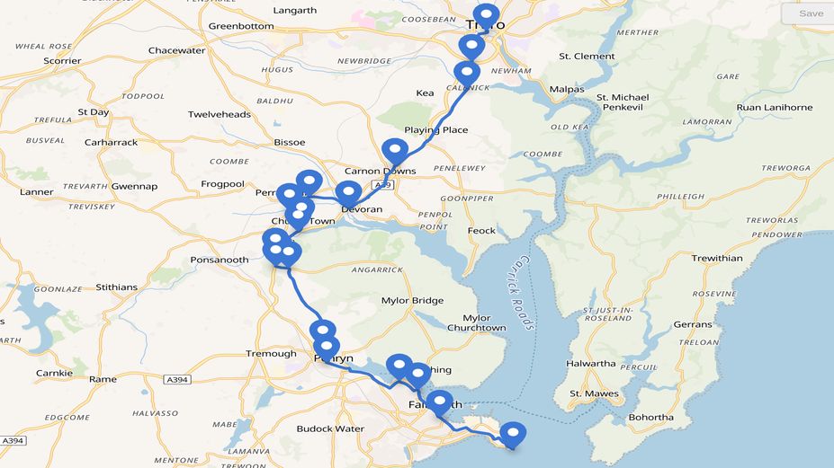
Stage One – Falmouth to Truro
Distance: 11.5 MILES (18.3KM)
Elevation: 457 metres
Stage Metrics & Terrain
- Distance: ~11.5 miles / 18.5 km
- Terrain: Coastal paths, tidal riverbanks, wooded creeks, quiet country lanes, and historic city approaches.
- Overview: Traversing from the mouth of the Carrick Roads up the estuary to Truro Cathedral, this opening leg bridges Tudor maritime defense, packet-boat trade, Celtic heritage, and 19th-century mining routes.
2. Route & Historical Highlights
- Little Dennis & Pendennis Castle: Starts at the Tudor blockhouse at Pendennis Point, built by Henry VIII (1540–1545). Pendennis was one of the last Royalist strongholds to surrender during the Civil War in 1646.
- Custom House Quay & Fish Strand Quay: Home to the 19th-century King’s Pipe contraband chimney. Fish Strand Quay is the historic landing site for both Lt. John Lapenotiere (1805, bringing the Trafalgar Dispatches and news of Lord Nelson’s death) and Charles Darwin (1836, stepping off HMS Beagle after 5 years at sea).
- Sir Robin Knox-Johnston & The Chain Locker: In 1969, Knox-Johnston finished the world’s first non-stop solo circumnavigation in Falmouth after 312 days—having famously borrowed the pub’s Guinness barometer for the journey!
- Penryn Quay & Glasney College: Chartered in 1236, Penryn predates Falmouth. It housed Glasney College (1265), the medieval intellectual heart of Cornwall where the Cornish miracle plays (Ordinalia) were written.
- Mylor Churchtown: St Mylor Church sits beside a saltmarsh creek, featuring a 10-foot Cornish granite cross (the county’s tallest) marking the 6th-century martyr’s burial site.
- Devoran & Calenick Creek: Devoran was a thriving 19th-century copper and tin export port on the Redruth & Chasewater Railway. Calenick was an 18th-century tin-smelting hamlet leading into Truro.
- Truro Cathedral: The stage finishes at John Loughborough Pearson’s Gothic Revival cathedral, built between 1880 and 1910.
3. Literary Connections
- Kenneth Grahame: Wrote letters from Falmouth’s Greenbank Hotel in 1907 featuring Toad, Ratty, and Mole—the manuscript seeds for The Wind in the Willows.
- Daphne du Maurier: Drew inspiration from the Carrick Roads and Helford estuaries for Frenchman’s Creek.
- Beatrix Potter & P.G. Wodehouse: Both holidayed and sketched in Falmouth, capturing its wildlife and serene creek setting.
4. Trail Logistics & Refreshments
- Transport:
- Start (Falmouth): Long distance GWR trains connect via Maritime Line to Truro, run every hour; regular local Go Cornwall buses. (PLAN JOURNEY HERE)
- Finish (Truro): Mainline rail (GWR direct to Plymouth, Bristol, London Paddington) and central bus station on Green Street. (PLAN JOURNEY HERE)
- Food & Sanctuary Stops: Quayside cafes and pubs in Falmouth (Custom House Quay), historic inns in Penryn, and independent bakeries, and inns around Truro Cathedral. Accommodation is available in hotels and B&B’s
. Stage Metrics & Terrain
- Distance: ~11.5 miles / 18.5 km
- Terrain: Coastal paths, tidal riverbanks, wooded creeks, quiet country lanes, and historic city approaches.
- Overview: Traversing from the mouth of the Carrick Roads up the estuary to Truro Cathedral, this opening leg bridges Tudor maritime defense, packet-boat trade, Celtic heritage, and 19th-century mining routes.
2. Route & Historical Highlights
- Little Dennis & Pendennis Castle: Starts at the Tudor blockhouse at Pendennis Point, built by Henry VIII (1540–1545). Pendennis was one of the last Royalist strongholds to surrender during the Civil War in 1646.
- Custom House Quay & Fish Strand Quay: Home to the 19th-century King’s Pipe contraband chimney. Fish Strand Quay is the historic landing site for both Lt. Lapenotiere (1805, bringing the Trafalgar Dispatches and news of Nelson’s death) and Charles Darwin (1836, stepping off HMS Beagle after 5 years at sea).
- Sir Robin Knox-Johnston & The Chain Locker: In 1969, Knox-Johnston finished the world’s first non-stop solo circumnavigation in Falmouth after 312 days—having famously borrowed the pub’s Guinness barometer for the journey!
- Penryn Quay & Glasney College: Chartered in 1236, Penryn predates Falmouth. It housed Glasney College (1265), the medieval intellectual heart of Cornwall where the Cornish miracle plays (Ordinalia) were written.
- Mylor Churchtown: St Mylor Church sits beside a saltmarsh creek, featuring a 10-foot Cornish granite cross (the county’s tallest) marking the 6th-century martyr’s burial site.
- Devoran & Calenick Creek: Devoran was a thriving 19th-century copper and tin export port on the Redruth & Chasewater Railway. Calenick was an 18th-century tin-smelting hamlet leading into Truro.
- Truro Cathedral: The stage finishes at John Loughborough Pearson’s Gothic Revival cathedral, built between 1880 and 1910.
3. Literary Connections
- Kenneth Grahame: Wrote letters from Falmouth’s Greenbank Hotel in 1907 featuring Toad, Ratty, and Mole—the manuscript seeds for The Wind in the Willows.
- Daphne du Maurier: Drew inspiration from the Carrick Roads and Helford estuaries for Frenchman’s Creek.
- Beatrix Potter & P.G. Wodehouse: Both holidayed and sketched in Falmouth, capturing its wildlife and serene creek setting.
4. Trail Logistics & Refreshments
- Transport:
- Start (Falmouth): Maritime Line trains to Truro; regular local First Kernow buses.
- Finish (Truro): Mainline rail (GWR direct to Plymouth, Bristol, London Paddington) and central bus station on Green Street.
- Food & Sanctuary Stops: Harborside cafes and pubs in Falmouth (Custom House Quay), historic quayside inns in Penryn and Mylor, creek-side pubs in Restronguet/Devoran, and independent bakeries around Truro Cathedral
1. Stage Metrics & Terrain
- Distance: ~14.5 miles / 23.3 km
- Terrain: Woodland earthen tracks, rural footpaths, quiet country lanes, field margins, and tarmac coastal town approaches.
- Overview: Leaving the Gothic spires of Truro Cathedral behind, this leg cuts directly across the central spine of Cornwall toward the Atlantic coast. The trail climbs from urban river pavements through the cool canopy of Idless Woods and agricultural hinterlands, before dropping down to the cliff edge at Newquay.
2. Route & Historical Highlights
- Truro Cathedral & Daubuz Moors: Starts beneath John Loughborough Pearson’s Gothic Revival spires (built 1880–1910). The route passes through Daubuz Moors, named after Huguenot tin-smelter Lewis Charles Daubuz, passing beneath Brunel’s stone railway viaduct and the ruins of 19th-century Moresk Mill.
- Idless Woods (Bishop’s Wood): Quiet earthen tracks along the Allen River valley, following an ancient timber woodland. Features overgrown stone blast walls from a 19th-century gunpowder factory that supplied local Cornish mines, as well as an experimental plot of towering Eucalyptus trees.
- St Erme & Trispin: Sitting along the high ancient agricultural ridge that carried travelers across Cornwall for centuries, marked by medieval church paths and ancient field boundaries.
- Mitchell (formerly St Michael): A vital coaching halt during the turnpike era where horses were changed on the overland journey down the peninsula.
- Destination Focus (Newquay & Great Western Hotel): Originally the small pilchard-fishing hamlet of Towan Blystra (renamed after its “new quay” in the 15th century), the stage concludes at the cliffside Great Western Hotel beside the railway terminus—marking the dramatic shift from inland Cornwall to the wild Atlantic coastline.
3. History, Culture & Literary Threads
- The Inland Highway Vector: Traces the historic route of post-chaises, drovers, and foot travelers navigating between the English Channel and the North Coast.
- Gothic Revival vs. Ancient Celtic Ways: Pearson’s Victorian masterpiece in Truro provides a striking architectural contrast to the ancient rural parish boundaries and church paths crossed along the inland trail.
- Victorian Railway Era: The finish at the Great Western Hotel anchors the walk in the 1875 arrival of the Great Western Railway, which unlocked the rugged northern coast to writers, travelers, and ocean seekers.
4. Trail Logistics & Refreshments
- Transport Links:
- Start (Truro): Truro Railway Station (Cornish Main Line) and central bus station at Green Street.
- Finish (Newquay): Newquay Railway Station (Atlantic Coast Line terminus directly adjacent to the Great Western Hotel); central bus station for regional routes; Cornwall Airport Newquay (5 miles northeast).
- Food & Accommodation:
- Refreshments: Historic coaching inns in Mitchell, countryside cafes, Cornish pasty shops, harborside seafood bars, and cliffside bistros in Newquay.
- Accommodation: Historic railway-era hotels (like the Great Western Hotel itself), coastal B&Bs, independent hostels, and cliff-top lodgings in Newquay.
5. Stage Downloads & Interactive Map
1. Stage Metrics & Terrain
- Distance: ~16.5 miles / 26.5 km
- Terrain: High cliff paths, sandy coves, open plateau farmland, and historic estuary tracks.
- Overview: Bidding farewell to Newquay’s Atlantic cliffs, Stage 3 traces high coastal headlands before turning inland along ancient packhorse routes and plateau farmland. The trail weaves past Iron Age metallurgy forts, buried Saxon villages, and WWII Coastal Command bases, descending into the historic harbour of Padstow.
2. Route & Historical Highlights
- Trevelgue Head (Porth Island): Home to a massive Iron Age promontory fort guarded by eight distinct earthwork ramparts. Excavations revealed it as one of Europe’s earliest metal-working centers (with over 200 kg of bronze/iron slag) and site of a massive 14.5-meter tribal gathering roundhouse.
- Mawgan Porth & Vale of Lanherne: Features a buried 10th-century Late Saxon village excavated in the sand dunes. The valley leads toward Lanherne Convent, an ancient Arundell family stronghold that harbored Carmelite nuns fleeing the French Revolution in 1794.
- St Eval & WWII Coastal Command Base: Saint Eval Church stands beside a vital WWII Coastal Command airfield that flew anti-submarine patrols over the Western Approaches. The 13th-century church tower was saved from demolition in 1940 to serve as a vital visual beacon for returning pilots.
- Plateau Packhorse Routes & Holy Wells: Inland paths follow ancient Cornish hedges and medieval trade arteries, passing holy well sites dedicated to Celtic saints (St Ervan and St Petroc) used by early pilgrims crossing the peninsula.
- Padstow Harbour & The Old Custom House: The stage terminates at the 18th-century stone Old Custom House on South Quay, built to police Cornwall’s contraband trade and overlooking the legendary “Doom Bar” sandbank at the mouth of the Camel Estuary.
3. History, Culture & Literary Threads
- Ancient Metallurgy to Aviation History: A remarkable landscape transition—moving from Europe’s earliest prehistoric iron furnaces at Trevelgue Head straight into the mid-20th-century Battle of the Atlantic aviation hub at St Eval.
- The Celtic Pilgrim Cut-Through: Demonstrates how early travelers and pilgrims navigated inland across plateau footpaths to bypass the treacherous, storm-wracked waters of Land’s End.
- Folklore & Maritime Legend: The arrival at Padstow anchors the walk in local seafaring folklore, centered on the Doom Bar sandbank—legendarily created by a dying mermaid’s curse.
4. Trail Logistics & Refreshments
- Transport Links:
- Start (Newquay): Railway station (Atlantic Coast Line), central bus station, and local coastal bus connections.
- Finish (Padstow): Local bus links (Go Cornwall) connecting directly to Bodmin Parkway Railway Station (Main Line) and Wadebridge; seasonal passenger ferry across the estuary to Rock.
- Food & Refreshment:
- En Route: Beachside cafes at Porth and Mawgan Porth; village pubs near St Eval and Little Petherick.
- Padstow: World-famous harbour dining, traditional pasty bakeries, seafood bistros, and historic waterside inns around South Quay.
- Accommodation: Coastal guest houses, farm B&Bs along the plateau, cliffside inns, and harbour hotels in Padstow.
5. Stage Downloads & Interactive Map
1. Stage Metrics & Terrain
- Distance: ~23 miles / 37 km
- Terrain: Estuary ferry crossing, shifting sand dunes, rugged coastal cliffs, narrow rocky coves, and high ocean plateaus.
- Overview: Stage 4 crosses the Camel Estuary from Padstow to Rock before embarking on an epic, dramatic stretch of North Cornish coastline. Passing dunes, ghost fishing coves, and Dark Age Mediterranean trading posts at Tintagel, the leg culminates in the natural fjord-like harbour of Boscastle.
2. Route & Historical Highlights
- Rock Ferry & Camel Estuary: Crosses from Padstow to Rock via the ancient ferry. Historically, this water link allowed Irish and Welsh pilgrims to land safely on Cornwall’s north coast and trek overland, avoiding the deadly open-sea voyage around the infamous “Doom Bar” and Land’s End.
- St Enodoc Church (“Sinking Neddy”): Tucked into the dunes behind Daymer Bay, this church was almost completely buried by shifting sands between the 16th and 19th centuries. To retain parish status, the parson was annually lowered through a roof hatch to conduct services before its 1864 restoration. Poet Laureate Sir John Betjeman is buried in the churchyard.
- Port Quin & Port Isaac: Passes Port Quin, the famous “ghost cove” abandoned after a 19th-century gale destroyed its entire fishing fleet at sea. Port Isaac preserves rare 18th-century “pilchard palaces”—stone cellars where fish were salted and pressed for export to Catholic Europe.
- Tintagel Castle & Headland: Site of a 5th–7th century Dark Age royal citadel trading directly with Byzantium and North Africa (evidenced by thousands of Mediterranean pottery sherds), later crowned by Earl Richard’s 13th-century stone castle and steeped in Arthurian mythos.
- Boscastle Harbour & Witchcraft Museum: Concludes at Boscastle’s fjord-like inlet, protected by Elizabethan pier arms built in 1584 by Sir Richard Grenville. Home to the world-famous Museum of Witchcraft and Magic (founded 1960) and rebuilt following the dramatic 2004 flash flood.
3. History, Culture & Literary Threads
- Sir John Betjeman: The Poet Laureate lived nearby and immortalized St Enodoc Church and the surrounding dune landscape in his poetry.
- Arthurian Mythos: Merlin’s Cave and the Tintagel headland remain globally bound to King Arthur legends, popularized in Geoffrey of Monmouth’s 12th-century Historia Regum Britanniae.
- Folk Magic & Maritime Survival: Traces the stark realities of maritime catastrophe at Port Quin alongside centuries of Cornish folk magic and cunning traditions preserved at Boscastle.
4. Trail Logistics & Refreshments
- Transport Links:
- Start (Padstow): Local buses to Wadebridge/Bodmin Parkway; seasonal Black Tor passenger ferry across to Rock.
- Finish (Boscastle): Local bus services (Go Cornwall / First) connecting to Wadebridge, Camelford, and Bude.
- Food & Refreshment:
- En Route: Beachside cafes at Daymer Bay, historic inns and seafood cellars in Port Isaac and Tintagel.
- Boscastle: Harbour tearooms, traditional pubs, and local pasty bakeries around the Valency River basin.
- Accommodation: Coastal B&Bs, clifftop inns in Port Isaac and Tintagel, and historic harbour guesthouses in Boscastle.
5. Stage Downloads & Interactive Map
1. Stage Metrics & Terrain
- Distance: ~19 miles / 30.5 km
- Terrain: Wooded river valleys, deep inland farmland, ancient sunken lanes, moorland edge footpaths, and historic castle approaches.
- Overview: Stage 5 turns inland from Boscastle Harbour, tracking up the literary Valency Valley past Thomas Hardy’s landscape at St Juliot. The trail traverses deep rural farmland, passes Cornwall’s largest holy well at St Clether, and finishes at the formidable Norman keep of Launceston Castle—the historic gateway to Cornwall.
2. Route & Historical Highlights
- Valency Valley & Thomas Hardy’s St Juliot: The route climbs through the secluded Valency Valley (site of the catastrophic 2004 flash flood) to St Juliot Church. In 1870, young architect Thomas Hardy arrived to restore the church tower, meeting his first wife Emma Gifford and finding direct inspiration for A Pair of Blue Eyes and his Poems of 1912–13.
- St Clether & The Sacred Well of the Inny: Tucked in the River Inny valley, this 15th-century chapel complex (built on 5th-century Celtic foundations) is Cornwall’s best-preserved holy well site, featuring carved stone water channels and curing basins.
- Inland Salt Ways (Hallworthy & Egloskerry): Rural footpaths trace pre-turnpike trade routes used to haul sea salt, lime, and slate across the peninsula. St Keria’s Church at Egloskerry retains rare 12th-century Norman doorways and gentry monuments.
- Launceston Castle (Ancient Capital of Cornwall): Terminates at the traditional capital of Cornwall. Built shortly after the Conquest by Robert, Count of Mortain (William the Conqueror’s half-brother) to command the primary Tamar land border. Features a rare 13th-century round tower inside a 12th-century shell keep.
- George Fox & Doomsdale Dungeon: In 1656, Quakerism founder George Fox was imprisoned in the castle’s notorious “Doomsdale” dungeon for refusing to take an oath or remove his hat in court, a pivotal moment in early Quaker history.
3. History, Culture & Literary Threads
- Literary Roots: Thomas Hardy’s architectural work and romance at St Juliot forever tied this valley to 19th-century English literature.
- Celtic Faith & Healing Springs: The Holy Well of St Clether demonstrates the enduring pilgrimage tradition of seeking spiritual sanctuary and bodily curing at sacred natural springs along moorland edge paths.
- Norman Gateway & Dissent: Launceston Castle represents the iron grip of Norman rule over the Westcountry, contrasted with the radical spiritual dissent of George Fox standing against state authority.
4. Trail Logistics & Refreshments
- Transport Links:
- Start (Boscastle): Local buses (Go Cornwall) to Wadebridge, Camelford, and Bude.
- Finish (Launceston): Major regional bus hub at Westgate Street linking directly to Plymouth (Rail Station), Exeter, Bodmin, and Bude.
- Food & Refreshment:
- En Route: Country pubs in Hallworthy and Egloskerry; farm gate stands along the rural lanes.
- Launceston: Historic town-center coaching inns, independent cafes, traditional bakeries, and tea rooms around the castle grounds and butter market.
- Accommodation: Village B&Bs near St Juliot and Hallworthy; historic inns, guest houses, and hotels in Launceston town center.
5. Stage Downloads & Interactive Map
1. Stage Metrics & Terrain
- Distance: ~14.5 miles / 23.3 km
- Terrain: Historic river crossing, rural West Devon farmland, ancient estate paths, sunken lanes, and medieval border fortifications.
- Overview: Crossing Polson Bridge over the River Tamar, Stage 6 bids farewell to Cornwall and enters West Devon. The route follows agrarian ridge paths past Lifton manor and Lewtrenchard, ascending toward the Saxon earthworks and notorious Stannary prison keep at Lydford on the edge of Dartmoor.
2. Route & Historical Highlights
- Polson Bridge (The Tamar Border): Marks the historic entry into England established by King Athelstan in 936 AD. This vital land passage carried medieval royal armies, Civil War troops, and Prayer Book rebels.
- Lifton & Dippertown Drovers’ Paths: Passes the royal manor of Lifton (where Charles I stayed in 1644) before following ancient ridge paths down the Lew Valley with sweeping views toward Dartmoor.
- Lewtrenchard Manor & Sabine Baring-Gould: Ancestral home of Rev. Sabine Baring-Gould—the polymath, novelist, and hymn writer (Onward, Christian Soldiers) who travelled the West Country collecting traditional oral folk songs from elderly labourers to save them from extinction.
- Lydford Castle & Saxon Burh: Reaches the 9th-century fortified Saxon town built by Alfred the Great against Viking raids. Terminates at Lydford Castle, built in 1195 as the harsh prison for Dartmoor’s tin mining laws (Stannary Law), infamous for its severe “Lydford Law” justice.
- Optional Detour (Lydford Gorge): South of the village lies the deepest gorge in South West England, featuring the Whitelady Waterfall, Devil’s Cauldron, and historical caves once used as a hideout by the lawless “Gubbins” outlaw band.
3. History, Culture & Literary Threads
- Border Identities: Crossing the Tamar underscores the historic political and cultural boundary between the Kingdom of Cornwall and Saxon England.
- West Country Folk Music: Baring-Gould’s pioneering archival work at Lewtrenchard preserved the disappearing oral heritage of West Country farmhands and miners.
- Stannary Law vs. Outlaw Traditions: Lydford illustrates the extreme clash between state legal enforcement (Stannary Law) and the lawless border communities hiding in the depths of Lydford Gorge.
4. Trail Logistics & Refreshments
- Transport Links:
- Start (Launceston): Regional bus hub at Westgate Street linking to Plymouth, Exeter, and Bodmin.
- Finish (Lydford): Local bus connections (Go Cornwall / Oakleys) linking to Okehampton (Dartmoor Line rail service to Exeter) and Tavistock.
- Food & Refreshment:
- En Route: Farm-shop cafes near Lifton, country inns along the Lew Valley.
- Lydford: Historic village pubs (including the 16th-century Castle Inn) and local tearooms near the gorge entrance.
- Accommodation: Country house hotels, rural B&Bs around Lifton and Lewtrenchard, and traditional village inns in Lydford.
5. Stage Downloads & Interactive Map
. Stage Metrics & Terrain
- Distance: ~18.5 miles / 29.8 km
- Terrain: Shared-use converted railway path, dramatic high viaducts, granite moorland fringes, ancient oak woodlands, and historic stannary market tracks.
- Overview: Leaving Lydford along the conversion path of the former London and South Western Railway (Granite Way), Stage 7 crosses high wrought-iron viaducts and skirts the northern fringe of Dartmoor. Passing through the historic stannary town of Okehampton and ancient granite-walled lanes, the leg descends into Chagford.
2. Route & Historical Highlights
- The Granite Way & Meldon Viaduct: Follows the 1874 LSWR railway line used to transport Dartmoor granite. Crosses Meldon Viaduct—standing 150 feet above the West Okement River—one of only two surviving wrought-iron truss-arch railway bridges in Great Britain, overlooking Meldon Quarry.
- Okehampton Castle & Stannary Hub: Skirts Devon’s largest castle, built shortly after 1068 by Baldwin de Forde and later expanded by the Courtenay Earls. Okehampton became an official Stannary Town in 1305, serving as a primary administrative center for weighing and stamping Dartmoor tin.
- Belstone & Gidleigh Fringes: Passes Belstone (famous for the “Nine Maidens” stone circle folklore) and Gidleigh, home to a private 14th-century fortified granite keep built around 1324. The path winds through ancient Celtic-fringe oak woodlands and prehistoric field boundaries (reaves).
- Arrival at Chagford: Terminating in the historic market square of Chagford, chartered as a Stannary Town in 1305. Chagford prospered in the 15th and 16th centuries through tin mining and the Devon wool trade.
- The Three Hares & Civil War Heritage: St Michael’s Church in Chagford features the famous “Three Hares” roof boss, an esoteric motif tracing back to ancient Silk Road trade routes. Nearby, the Three Crowns Inn marks the 1643 Civil War skirmish site where Royalist poet Sidney Godolphin was killed.
3. History, Culture & Literary Threads
- Victorian Transport Infrastructure: The Granite Way demonstrates how 19th-century railway engineering opened up isolated Westcountry moorland communities to industrial trade.
- Esoteric Trade Motifs: The Three Hares emblem links Dartmoor’s tin trade to ancient global trade arteries stretching all the way back to Buddhist cave temples in Dunhuang, China.
- Medieval Stannary Administration: Both Okehampton and Chagford highlight the immense legal and financial power wielded by the Duchy of Cornwall’s medieval tin coinage system.
4. Trail Logistics & Refreshments
- Transport Links:
- Start (Lydford): Local buses connecting to Okehampton and Tavistock.
- Mid-Stage (Okehampton): Okehampton Railway Station (Dartmoor Line services direct to Exeter St Davids); central bus interchange.
- Finish (Chagford): Bus connections (Dartline) to Moretonhampstead, Exeter, and Newton Abbot.
- Food & Refreshment:
- En Route: Granite Way railway cafes, pubs and bakeries in Okehampton town center, village tearooms in Belstone.
- Chagford: Historic coaching inns (including the Three Crowns), artisan bakeries, organic cafes, and traditional pubs around the medieval square.
- Accommodation: Town hotels and B&Bs in Okehampton; country guest houses, historic inns, and boutique lodgings in Chagford.
5. Stage Downloads & Interactive Map
1. Stage Metrics & Terrain
- Distance: ~16.5 miles / 26.5 km
- Terrain: Deep river gorges, ancient oak woodlands, waterside valley trails, steep granite-walled lanes, and historic mining villages.
- Overview: Leaving Chagford along the River Teign, Stage 8 traverses the dramatic Teign Gorge below Britain’s newest granite castle. Following packhorse tracks and wild daffodil reserves down the Teign Valley past silver-lead mining hamlets, the leg climbs to the 16th-century Nobody Inn at Doddiscombsleigh.
2. Route & Historical Highlights
- Teign Gorge & Castle Drogo: Follows the River Teign beneath Hunters Tor through ancient sessile oak woods. Overlooking the gorge stands Castle Drogo, designed by Sir Edwin Lutyens for Julius Drewe (built 1910–1930)—the last granite castle constructed in England.
- Fingle Bridge & Iron Age Forts: Crosses a Grade II* listed 17th-century stone packhorse bridge, guarded above by two massive Iron Age hillforts (Wooston Castle and Prestonbury Castle).
- Dunsford Reserve & Step Bridge: Passes through riverbank reserves famous for wild native daffodils and ancient coppiced hazel woodland, where river-bed granite boulders were historically worked by local stonemasons.
- Christow & Silver-Lead Mines: Traces the Teign Valley’s 17th–20th century mining district (famous for silver, lead, and barytes at Frankmills Mine). St Teilo’s Church in Christow retains a 15th-century rood screen and an authentic 1645 Civil War cannonball.
- Doddiscombsleigh, St Michael’s & The Nobody Inn: Winds up to Doddiscombsleigh, terminating at the 16th-century timber-framed Nobody Inn (famous for its eccentric landlord legend). Adjacent St Michael’s Church contains Devon’s finest collection of 15th-century Exeter-crafted stained glass depicting the Seven Sacraments.
3. History, Culture & Literary Threads
- 20th-Century Revivalist Architecture: Lutyens’ grand granite construction at Castle Drogo presents a dramatic architectural contrast to the ancient, humble timber-framed inns and field walls below.
- Valley Ecology & Charcoal Traditions: The Teign Gorge woodland preserves ancient charcoal-burning hearths and rare lichens, demonstrating centuries of traditional coppice management.
- Civil War Artifacts & Medieval Glass: From the 1645 cannonball at Christow to the exquisite 15th-century Seven Sacraments stained glass at Doddiscombsleigh, this stage bridges brutal wartime conflict and medieval devotional art.
4. Trail Logistics & Refreshments
- Transport Links:
- Start (Chagford): Regional bus links (Dartline) to Moretonhampstead, Exeter, and Newton Abbot.
- Mid-Stage (Dunsford/Christow): Local bus services (Country Bus / Stagecoach) linking through the Teign Valley to Exeter.
- Finish (Doddiscombsleigh): Rural lane connections; nearest main bus links at Lower Ashton or Dunsford; taxi access to Exeter St Davids Railway Station.
- Food & Refreshment:
- En Route: Castle Drogo tearooms, waterside refreshments at the historic Fingle Bridge Inn, village pubs in Dunsford and Christow.
- Doddiscombsleigh: The famous Nobody Inn offering historic pub dining, real ales, and local produce.
- Accommodation: Village B&Bs around Dunsford and Christow; country guest rooms and historic lodgings at The Nobody Inn.
5. Stage Downloads & Interactive Map
1. Stage Metrics & Terrain
- Distance: ~19.5 miles / 31.4 km
- Terrain: Country lanes, Haldon ridge footpaths, historic city cobbles, and a flat, multi-use estuary trail along tidal marshlands.
- Overview: Leaving The Nobody Inn, Stage 9 crosses Haldon Hills into the Roman-walled city of Exeter and its world-famous Cathedral. Following the Exe Estuary Trail past Dutch merchant ports and Royal Marine training grounds, the stage reaches Exmouth—the western gateway to the Jurassic Coast.
2. Route & Historical Highlights
- Ide & Haldon Approach: Drops off Haldon Hills into Ide, a historic orchard village that served as a medieval agricultural breadbasket feeding Exeter.
- Exeter Cathedral & City Walls: Reaches the 1050 AD Cathedral Church of Saint Peter, featuring the longest uninterrupted medieval Gothic vaulted ceiling in the world ($96\text{ meters}$). The library houses the 10th-century Exeter Book (containing a tenth of all surviving Old English poetry). The route crosses 2,000-year-old Roman city walls.
- Exe Estuary Trail & Topsham: Follows Exeter Quayside to Topsham Harbour, an 18th-century cotton export hub famous for its “Dutch gable” merchant houses constructed from Dutch ship-ballast bricks.
- Lympstone & Shellfish Beds: Winds through narrow drangway lanes past Peters Tower (1860) and historic estuary oyster beds, skirting the perimeter of the Royal Marines Commando Training Centre (CTCRM Lympstone).
- Arrival at Exmouth (Jurassic Coast Gateway): Concludes at Devon’s oldest seaside resort, marking the official western terminus of the UNESCO World Heritage Jurassic Coast where Devonian slate transitions into 250-million-year-old Triassic red sandstone cliffs.
3. History, Culture & Literary Threads
- The Exeter Book: Preserved at Exeter Cathedral, this invaluable 10th-century codex preserves fundamental Old English poetry, riddles, and elegies that form the bedrock of early English literature.
- Anglo-Dutch Maritime Commerce: Topsham’s unique Dutch gable architecture stands as physical evidence of the 17th-century wool and cotton trade routes spanning the North Sea.
- Triassic Geological Frontier: Exmouth marks the sudden geological shift from ancient interior granite to the red sandstone cliffs that begin the story of the Jurassic Coast.
4. Trail Logistics & Refreshments
- Transport Links:
- Start (Doddiscombsleigh): Taxi link to Exeter or bus connection at Lower Ashton/Dunsford.
- Mid-Stage (Exeter / Topsham): Exeter St Davids & Central Railway Stations; main city bus interchange; Avocet Line train stations at Topsham and Lympstone.
- Finish (Exmouth): Exmouth Railway Station (Avocet Line terminus to Exeter); major regional bus terminal; seasonal passenger ferries across the estuary mouth to Dawlish Warren.
- Food & Refreshment:
- En Route: Village pubs in Ide, Exeter Cathedral Green cafes and historic taverns, Topsham waterfront pubs, Lympstone seafood bars.
- Exmouth: Traditional seaside tearooms, harbourside fish restaurants, pasty bakeries, and oceanfront bistros.
- Accommodation: Full range of options in Exeter city center, estuary B&Bs in Topsham and Lympstone, and coastal hotels, inns, and guest houses in Exmouth.
5. Stage Downloads & Interactive Map
1. Stage Metrics & Terrain
- Distance: ~16.7 miles / 27.0 km (~18.5 miles including full coastal loops)
- Terrain: Seafront promenades, converted railway greenways, rural woodland lanes, floodplain river paths, dramatic Triassic cliff paths, and pebble beaches.
- Overview: Bypassing standard coastal detours, Stage 10 takes the “Heritage Bypass” vector—climbing from Exmouth’s Triassic cliffs at Orcombe Point to the inland churchyard where Lady Nelson rests. The trail follows a leafy rail greenway to Sir Walter Raleigh’s thatched birthplace, before descending to the River Otter estuary and ascending high red-and-chalk sea cliffs into the smuggling cove of Beer.
2. Route & Historical Highlights
- Orcombe Point & St Margaret’s Church, Littleham: Leaves Exmouth via the Geoneedle at Orcombe Point. Turns inland to Littleham Churchyard, site of the tomb of Frances “Fanny” Nelson (Lady Nelson, 1761–1831), widow of Admiral Lord Nelson. Granted to Sherborne Abbey monks in 1042, the village retains medieval cob walls.
- Exmouth-to-Budleigh Rail Trail (NCN Route 2): Traces the traffic-free trackbed of the former 1897 LSWR branch line (closed in 1967), now a leafy wildlife sanctuary for deer, badgers, and songbirds.
- Hayes Barton & East Budleigh: Passes Hayes Barton, the Grade I listed, thatched 16th-century cob farmhouse where Sir Walter Raleigh was born in 1552. Continues to East Budleigh square (featuring Raleigh’s bronze statue) and All Saints’ Church, home to the 1537 carved Raleigh family pew and his mother’s tomb.
- White Bridge & River Otter Estuary: Drops through field paths across the River Otter floodplain to White Bridge, bypassing town pavements and positioning walkers at the foot of the eastern cliff ascents.
- Red Cliffs, Sidmouth & Beer Harbour: Rejoins the coast at Ladram Bay, traversing 250-million-year-old Triassic red sandstone sea stacks. Passes through Victorian Sidmouth, climbing where red sandstone transitions into Cretaceous white chalk at Beer Head. Concludes in the pebbled cove of Beer, famous for underground Beer Stone quarries (used in Exeter Cathedral and the Tower of London) and the smuggling exploits of Jack Rattenbury.
3. History, Culture & Literary Threads
- Naval & Elizabethan Empire Builders: Bridges two pivotal eras of ocean expansion—from Sir Walter Raleigh’s 16th-century Elizabethan voyages inspired by the River Otter to Lady Nelson’s quiet 19th-century retirement following Trafalgar.
- Geotectonic Transition Zone: Demonstrates the living story of the Jurassic Coast, where red Triassic iron-oxide rocks give way to white Cretaceous chalk cliffs around Beer Head.
- Underground Quarrying & Smuggling: Beer’s isolated geography fostered a rich dual heritage of underground stone masonry and 18th-century contraband trade.
4. Trail Logistics & Refreshments
- Transport Links:
- Start (Exmouth): Railway terminus (Avocet Line to Exeter); central bus station; seasonal ferry connections.
- Mid-Stage (East Budleigh / Sidmouth): Local bus services (Stagecoach / Axe Valley) linking East Budleigh, Budleigh Salterton, and Sidmouth to Exeter and Honiton.
- Finish (Beer): Local bus links (Axe Valley / Stagecoach) to Seaton, Axminster Railway Station (London Waterloo line), and Sidmouth.
- Food & Refreshment:
- En Route: Village pubs in Littleham and East Budleigh, coastal tearooms at Ladram Bay, wide dining options along Sidmouth seafront and Branscombe Mouth.
- Beer: Fresh seafood stalls, beachside cafes, traditional smugglers’ pubs, and village bakeries around the harbour.
- Accommodation: Estuary B&Bs near East Budleigh; historic seafront hotels in Sidmouth; cliffside inns, fishing cottages, and guest houses in Beer.
5. Stage Downloads & Interactive Map
- Distance: 33.1 km / 20.5 miles
- Ascent: 1,072 meters
- Terrain: Coastal paths, converted woodland tracks, quiet rural green lanes, and low-level valley river footpaths.
- Overview: Bypassing the extreme coastal drops of Golden Cap in bad weather, Stage 11 follows the Undercliff into Lyme Regis and Charmouth. Turning inland along the River Char valley, pilgrims visit the unbroken medieval relic shrine of St Wite at Whitchurch Canonicorum before walking quiet lanes through Ryall and North Chideock over Eype Down to West Bay Harbour.
2. Route & Historical Highlights
- Beer to Axmouth Undercliff: Departs Beer High Street, crossing the River Axe into the 400-acre Undercliff nature reserve—a sheltered woodland wilderness formed by the 1839 Bindon Landslip.
- Lyme Regis & Charmouth: Passes Mary Anning’s fossil beaches and the 13th-century Cobb breakwater in Lyme Regis before following the coast into Charmouth.
- River Char Valley & Whitchurch Canonicorum: Follows the River Char inland to the Church of St Candida and Holy Cross. Houses the only complete parish church saint’s shrine in England to survive the Reformation with its 9th-century relics intact.
- Ryall, North Chideock & West Bay: Continues along green lanes through Ryall and North Chideock, crossing over Eype Down to finish beside the golden Jurassic cliffs of West Bay.
3. History, Culture & Literary Threads
- Unbroken Medieval Relic Shrine: St Wite’s 13th-century stone tomb stands as an unbroken physical link to pre-Reformation Saxon pilgrimage traditions.
- Literary & Geological Frontiers: Connects Jane Austen’s Lyme Regis (Persuasion) with the 180-million-year-old golden sandstone cliffs of West Bay.
4. Trail Logistics & Refreshments
- Transport Links:
- Start (Beer): Local bus links (Axe Valley) to Seaton and Axminster Railway Station.
- Mid-Stage (Lyme Regis / Charmouth): Jurassic Coaster buses (First Bus X51/X53) to Axminster Rail Station and Bridport.
- Finish (West Bay): Local buses to Bridport, Dorchester (Main Line Rail), and Weymouth.
- Food & Refreshment:
- En Route: Bakeries in Lyme Regis and Charmouth; historic pub stops at The Royal Oak (Whitchurch Canonicorum) and inns in Chideock.
- West Bay: Harbour kiosks, seafood eateries, riverside tearooms, and waterside pubs.
- Accommodation: Coastal inns in Lyme Regis; village B&Bs in Charmouth and Chideock; harbour hotels in West Bay.
5. Stage Downloads & Interactive Map
1. Stage Metrics & Terrain
- Distance: 26.5 km / 16.5 miles
- Ascent: ~750 meters
- Terrain: Coastal paths, shingle beaches, high chalk ridgeway tracks, ancient green lanes, and Roman approach roads.
- Overview: Connecting the Jurassic coast to Dorchester, Stage 12 climbs over the high South Dorset Ridgeway to Abbotsbury Abbey. Passing prehistoric barrows, the route reaches Maiden Castle—the official 333km halfway point of the trail and location of the future Foster Powell Milestone—before descending into Dorchester.
2. Route & Historical Highlights
- West Bay to Hive Beach: Leaves West Bay along East Cliff and freshwater marshes toward the golden shingle banks of Burton Bradstock.
- Abbotsbury Abbey & St Catherine’s Chapel: Explores 11th-century abbey ruins and climbs to St Catherine’s Chapel—a 15th-century maritime sanctuary beacon.
- South Dorset Ridgeway & Hell Stone: Ascends the chalk uplands past ancient Neolithic dolmens and Bronze Age barrows.
- Maiden Castle (Halfway Point & Foster Powell Marker): Traverses Europe’s largest Iron Age hillfort, marking the official halfway milestone honoring long-distance pedestrian statesman Foster Powell, before descending into Roman Dorchester (Durnovaria).
3. History, Culture & Literary Threads
- The Official Halfway Milestone: Honors 18th-century athletic walker Foster Powell at Maiden Castle, establishing a focal point for long-distance endurance along the 666km corridor.
- Monastic Coastal Refuge: Abbotsbury’s chapel and abbey recall medieval systems of sanctuary and prayer established along treacherous shores.
- Literary Casterbridge: Celebrates the heritage of Thomas Hardy, whose Wessex novels animate Dorchester’s streets and surrounding chalk downs.
4. Trail Logistics & Refreshments
- Transport Links:
- Start (West Bay): Regular bus services to Bridport, Dorchester, and Weymouth.
- Finish (Dorchester): Dual mainline rail stations (Dorchester South to London Waterloo; Dorchester West to Bristol) and regional bus hubs.
- Food & Refreshment: Beach cafes at Hive Beach; tearooms and historic pubs in Abbotsbury; extensive dining across Dorchester town center.
- Accommodation: Coastal inns near West Bay; village guest houses; heritage hotels in Dorchester.
5. Stage Downloads & Interactive Map
1. Stage Metrics & Terrain
- Distance: 38.0 km / 23.6 miles
- Ascent: ~320 meters
- Terrain: River water-meadow paths, woodland tracks, quiet green lanes, and flat converted railway trailways.
- Overview: A long, historical stage connecting Dorchester (Casterbridge) to Blandford Forum. Visiting Maumbury Rings, Stinsford Church, Hardy’s Cottage, Athelhampton, and the Tolpuddle Martyrs’ Tree, the route crosses Crawford Bridge over the River Stour to finish along the North Dorset Trailway.
2. Route & Historical Highlights
- Maumbury Rings to Stinsford: Departs the Neolithic henge across Frome water-meadows to Hardy’s heart burial site at Stinsford Church.
- Hardy’s Cottage & Puddletown Forest: Traces Thorncombe Wood to Hardy’s thatch birthplace at Higher Bockhampton and crosses Rainbarrow (Egdon Heath).
- Athelhampton to Tolpuddle: Passes moated Athelhampton House to reach the Tolpuddle Martyrs’ Tree and memorial churchyard.
- Crawford Bridge & Trailway to Blandford: Crosses the 15-arched medieval stone Crawford Bridge at Spetisbury, cruising along the North Dorset Trailway into Georgian Blandford Forum.
3. History, Culture & Literary Threads
- Literary Footprints: Connects Thomas Hardy’s birthplace, parish church, and iconic Wessex landscapes.
- Sanctuary & Social Justice: Honours the 1834 Tolpuddle Martyrs who stood against starving wages beneath the village sycamore.
- Georgian Rebuilding: Celebrates Blandford Forum’s 18th-century architecture created following the Great Fire of 1731.
4. Trail Logistics & Refreshments
- Transport Links:
- Start (Dorchester): Mainline rail stations (Dorchester South & West) and regional bus hubs.
- Finish (Blandford Forum): Direct bus connections to Poole, Bournemouth, Dorchester, Shaftesbury, and Salisbury.
- Food & Refreshment: Tea rooms in Tolpuddle and Athelhampton; historic pubs in Puddletown, Spetisbury, and Blandford market square.
- Accommodation: Historic coaching inns and town hotels in Dorchester and Blandford Forum; village B&Bs in Tolpuddle and Puddletown.
5. Stage Downloads & Interactive Map
- Stage Metrics & Terrain
- Distance: 35.0 km / 22.0 miles
- Ascent: Moderate rolling downland climbs followed by a long, steady valley descent.
- Terrain: Asphalt pedestrian footways, chalk downland bridleways, grassy ridgeways, and valley water-meadow paths.
- Overview: A sweeping downland-to-valley stage forging a direct line from Dorset into Wiltshire. Following the historic Trafalgar dispatch corridor through Pimperne, Cashmoor, and Woodyates, the route crosses ancient linear earthworks at Martin Down before descending into the Ebble Valley to follow river water-meadows through Broad Chalke into medieval Salisbury.
- Route & Historical Highlights
- Blandford Forum to Pimperne: Departs The Crown Hotel via the Salisbury Road pedestrian footway straight into Pimperne village.
- Pimperne to Woodyates: Follows chalk bridleways parallel to the old turnpike across Cranborne Chase to the historic Woodyates Inn staging post.
- Martin Down to Ebble Valley: Crosses the massive earthworks of Bokerley Dyke and Roman Ackling Dyke at Martin Down Reserve, descending into Broad Chalke.
- Ebble Valley to Salisbury: Traces water-meadow paths through Stratford Tony and Harnham Water Meadows straight into Salisbury Cathedral Close.
- History, Culture & Literary Threads
- The Trafalgar Vector: Traces Lt. Lapenotiere’s 1805 dispatch ride carrying news of Nelson’s victory at Trafalgar through Woodyates.
- Prehistoric & Roman Frontiers: Crosses Bokerley Dyke and the raised agger of Roman Ackling Dyke across open chalk grassland.
- Cathedral Majesty: Concludes at 13th-century Salisbury Cathedral, home to the 1215 Magna Carta and Britain’s tallest spire.
- Trail Logistics & Refreshments
- Transport Links:
- Start (Blandford Forum): Bus connections to Poole, Bournemouth, Dorchester, Shaftesbury, and Salisbury.
- Finish (Salisbury): Major railway station with direct links to London Waterloo, Bristol, Exeter, and Southampton.
- Food & Refreshment: Country pubs and village shops along the route; extensive cafes, historic inns, and restaurants around Salisbury Market Place.
- Accommodation: Historic coaching inns, city hotels, boutique B&Bs, and guest houses within Salisbury city center and the Cathedral Close.
- Stage Downloads & Interactive Map
STAGE 15: SALISBURY TO WINCHESTER — 24.6 miles (39.6 km) | The Clarendon Way, Clarendon Palace, River Test & Winchester Cathedral
Accordion Expanded Content (Open State)
- Stage Metrics & Terrain
- Distance: 39.6 km / 24.6 miles Unknown
- Ascent: ~720 meters total ascent. Unknown
- Terrain: Chalk downland bridleways, woodland tracks, chalk-stream river bridges, and paved cathedral approaches. Unknown
- Overview: A classic 24.6-mile pilgrimage link following the historic Clarendon Way between two medieval cathedral cities. Passing the atmospheric ruins of Clarendon Palace, the route crosses the River Test and Farley Mount before descending into Saxon Winchester. Unknown+ 1
- Route & Historical Highlights
- Salisbury to Clarendon Palace: Exits Salisbury Cathedral Precinct east, climbing through Clarendon Wood to the ruins of Henry II’s royal palace. Unknown
- Pitton to King’s Somborne: Follows rural downland tracks and ancient woodland across the Wiltshire/Hampshire border into the River Test valley. Unknown
- Farley Mount to Winchester: Climbs through Farley Mount Country Park past its landmark pyramid monument, descending smoothly into Winchester. Unknown
- Cathedral Finish: Concludes at Winchester Cathedral, burial place of Anglo-Saxon monarchs and Jane Austen. Unknown
- History, Culture & Literary Threads
- Royal Foundations: Links Henry II’s 12th-century palace earthworks at Clarendon to King Alfred’s Saxon capital.
- Chalk-Stream Heritage: Crosses the renowned crystal waters of the River Test in Hampshire.
- Wessex Spire to Nave: Connects Salisbury’s soaring spire to the longest Gothic nave in Europe at Winchester.
- Trail Logistics & Refreshments
- Transport Links:
- Start (Salisbury): Major rail hub with direct lines to London Waterloo, Bristol, Exeter, and Portsmouth.
- Finish (Winchester): Fast mainline rail to London Waterloo, Southampton, and the Midlands.
- Food & Refreshment: Country pubs in Pitton, Middle Winterslow, and King’s Somborne; extensive tearooms and restaurants in Winchester city center.
- Accommodation: Range of historic coaching inns, boutique B&Bs, and hotels in both Salisbury and Winchester.
- Stage Downloads & Interactive Map
- Stage Metrics & Terrain
- Distance: 31.0 km / 19.3 miles
- Ascent: ~240 meters total ascent.
- Terrain: River water-meadow paths, quiet countryside lanes, gravel estate tracks, and gentle agricultural field margins.
- Overview: A serene 19.3-mile river and valley stage following St Swithun’s Way out of Winchester. Tracing the River Itchen water-meadows through Itchen Abbas and New Alresford, the route crosses gentle Hampshire downland to finish in the historic market town of Alton.
- Route & Historical Highlights
- Winchester to Itchen Abbas: Exits Winchester Cathedral precinct along the River Itchen meadows through Kings Worthy.
- Itchen Abbas to New Alresford: Follows river-valley paths and quiet lanes to the medieval Great Weir at Alresford.
- New Alresford to Bishop’s Sutton: Passes Georgian Alresford and the Watercress Line steam railway to Norman St Nicholas Church.
- Bishop’s Sutton to Alton: Traces quiet farmland tracks and green lanes across the Hampshire ridge into historic Alton.
- History, Culture & Literary Threads
- Pilgrimage Heritage: Re-traces the ancient medieval Pilgrims’ Way from St Swithun’s shrine toward Canterbury.
- Literary & Heritage Railway: Connects the birthplace of the watercress trade and Jane Austen’s writing home at Chawton.
- Civil War History: Concludes at Alton’s St Lawrence Church, site of the dramatic 1643 Civil War battle.
- Trail Logistics & Refreshments
- Transport Links:
- Start (Winchester): Mainline railway station with fast links to London Waterloo, Southampton, and the Midlands.
- Finish (Alton): Direct South Western Railway mainline services to London Waterloo and the heritage Watercress Line.
- Food & Refreshment: Country pubs in Itchen Abbas, Cheriton, and Bishop’s Sutton; tea rooms and historic pubs in Alresford and Alton market square.
- Accommodation: Historic coaching inns, town hotels, and guest houses in Winchester, Alresford, and Alton.
- Stage Downloads & Interactive Map
- Stage Metrics & Terrain
- Distance: 36.2 km / 22.5 miles
- Ascent: ~380 meters total ascent.
- Terrain: River water meadows, ancient sunken lanes, sandy heathland, and chalk ridge tracks along the North Downs threshold.
- Overview: A transformative 22.5-mile cross-county stage linking Hampshire to Surrey. Tracing St Swithun’s Way along the River Wey past Holybourne and Bentley to Farnham, the route joins the North Downs Way, climbing through Puttenham Common and St Martha’s Hill into medieval Guildford.
- Route & Historical Highlights
- Alton to Bentley: Follows St Swithun’s Way through Hampshire water meadows and picturesque villages along the River Wey.
- Bentley to Farnham: Crosses quiet farmland into the historic market town of Farnham, passing medieval Farnham Castle.
- Farnham to Puttenham: Marks the official start of the North Downs Way, traversing sandy tracks and pine woodland across Puttenham Common.
- Puttenham to Guildford: Climbs ancient sunken lanes over panoramic St Martha’s Hill before a steep descent down to the River Wey and Guildford High Street.
- History, Culture & Literary Threads
- Boundary & Ridge Pivot: Marks the monumental transition from St Swithun’s Way to the North Downs Way at Farnham Castle.
- Sacred Heights: St Martha-on-the-Hill stands as an iconic landmark along the ancient pilgrimage road to Canterbury.
- Artistic & Civic Heritage: Passes near the Victorian legacy of Watts Gallery at Compton and descends into Guildford’s medieval center.
- Trail Logistics & Refreshments
- Transport Links:
- Start (Alton): Direct South Western Railway mainline services to London Waterloo and connection to the Watercress Line.
- Intermediate (Farnham): Mainline railway links to London Waterloo, Alton, and Guildford.
- Finish (Guildford): Major railway hub with frequent services to London Waterloo, Portsmouth, and Reading.
- Food & Refreshment: Village pubs in Holybourne and Bentley; extensive cafes, tea rooms, and inns in Farnham, Puttenham, and Guildford.
- Accommodation: B&Bs, historic coaching inns, and hotels in Farnham, Puttenham, and central Guildford.
- Stage Downloads & Interactive Map
- Stage Metrics & Terrain
- Distance: 33.5 km / 20.8 miles
- Ascent: ~580 meters total ascent.
- Terrain: Open chalk grassland, ancient beech woodland, steep stepped ascents/descents, and ridge-crest tracks.
- Overview: A high, dramatic 20.8-mile ridge-line stage through the heart of the Surrey Hills AONB. Following the North Downs Way from Guildford, the trail traverses Newlands Corner, Ranmore Common, and Box Hill before crossing the River Mole and following the escarpment over Reigate Hill into Reigate.
- Route & Historical Highlights
- Guildford to Newlands Corner: Ascends out of Guildford via Pewley Down to the iconic viewpoint at Newlands Corner.
- Newlands Corner to Ranmore Common: Traverses woodland paths and high downs, passing St Barnabas Church on Ranmore Common.
- Ranmore Common to Box Hill: Skirts Denbies Wine Estate, descends to the River Mole stepping stones, and climbs Box Hill.
- Box Hill to Reigate: Follows the high ridge past Betchworth Quarry and Reigate Fort before descending into historic Reigate.
- History, Culture & Literary Threads
- Ancient Escarpment Trail: Traces the dramatic chalk ridge that has served as a primary east-west transport corridor for millennia.
- Natural Heritage & Conservation: Traverses famous National Trust reserves at Box Hill and Reigate Hill, rich in rare chalk-downland flora and butterflies.
- Victorian & Military Defense: Passes the 19th-century London Mobilisation Centre at Reigate Fort, built to defend the capital.
- Trail Logistics & Refreshments
- Transport Links:
- Start (Guildford): Major railway hub with frequent mainline services to London Waterloo, Portsmouth, and Reading.
- Intermediate (Dorking / Box Hill): Railway stations (Dorking, Box Hill & Westhumble) with direct links to London Victoria and Waterloo.
- Finish (Reigate): Reigate railway station with frequent connections to Redhill, London Victoria, and Gatwick Airport.
- Food & Refreshment: Visitor centers and cafes at Newlands Corner and Box Hill; estate cafe at Denbies; historic pubs in Westhumble, Betchworth, and Reigate.
- Accommodation: B&Bs, boutique hotels, and guest houses in Dorking, Westhumble, and central Reigate.
- Stage Downloads & Interactive Map
- Stage Metrics & Terrain
- Distance: 36.7 km / 22.8 miles
- Ascent: ~560 meters total ascent.
- Terrain: Chalk escarpment paths, beech woodland tracks, valley footpaths, and quiet rural Kentish lanes.
- Overview: A momentous 22.8-mile cross-county stage linking Surrey to Kent. Following the North Downs Way from Reigate past Merstham and Titsey, the trail enters Kent, visits historic Otford in the Darent Valley, and follows the escarpment foot to Wrotham.
- Route & Historical Highlights
- Reigate to Merstham & Titsey: Climbs back to the ridge, tracing high chalk downs past Merstham to the historic Titsey Estate.
- Titsey to Otford: Crosses the county boundary into Kent, skirting Chevening Park to reach the medieval pilgrimage hub of Otford.
- Otford to Kemsing: Follows valley paths and countryside margins past St Edith’s historic well in Kemsing village.
- Kemsing to Wrotham: Traverses quiet paths along the Kent Downs escarpment before descending into historic Wrotham.
- History, Culture & Literary Threads
- County Boundary & Pilgrims’ Way: Marks the transition from Surrey into Kent along paths walked by Canterbury pilgrims for centuries.
- Archbishop’s Heritage: Features the historic remains of Otford Palace, once one of the grandest archiepiscopal palaces in England.
- Rural Heritage: Connects historic estate landscapes at Titsey and Chevening within the designated Kent Downs Area of Outstanding Natural Beauty.
- Trail Logistics & Refreshments
- Transport Links:
- Start (Reigate): Railway station with direct links to Redhill, London Victoria, and Gatwick Airport.
- Intermediate (Merstham / Otford): Railway stations with direct links to London Victoria, Blackfriars, and Sevenoaks.
- Finish (Wrotham): Nearby Borough Green & Wrotham station with direct Southeastern services to London Victoria and Ashford International.
- Food & Refreshment: Cafes and pubs in Merstham, Otford, Kemsing, and Wrotham village square.
- Accommodation: Country inns, village B&Bs, and guest houses in Otford, Kemsing, Wrotham, and nearby Borough Green.
- Stage Downloads & Interactive Map
Stage Metrics & Terrain
- Distance: 30.5 km / 19.0 miles
- Ascent: ~490 meters total ascent.
- Terrain: Elevated chalk escarpment paths, ancient beech and oak woodland tracks, river valley bridge crossings, and quiet country lanes.
- Overview: A fascinating 19.0-mile ridge and valley stage through the Kent Downs AONB. Following the North Downs Way from Wrotham, the route crosses the River Medway at Cuxton, climbs past ancient megalithic sites at Blue Bell Hill, and traverses Detling Hill to medieval Thurnham.
- Route & Historical Highlights
- Wrotham to Cuxton: Traces ancient chalk tracks beneath Holly Hill before descending off the ridge into the Medway Valley.
- Medway Crossing to Blue Bell Hill: Crosses the River Medway via the bridge corridor and re-ascends the eastern escarpment toward Blue Bell Hill.
- Blue Bell Hill to Detling: Passes historic prehistoric sites including Kit’s Coty House and traverses White Horse Wood Country Park.
- Detling to Thurnham: Follows high woodland trails and escarpment crest paths down to the peaceful village of Thurnham and its castle ruins.
- History, Culture & Literary Threads
- Prehistoric Landscapes: Traverses the famous Medway Megaliths, including Neolithic long barrows and chambered tombs that predate Stonehenge.
- Strategic Medway Gap: Crosses the historical River Medway barrier, a crucial transport and defense corridor since Roman times.
- Castle & Defense Heritage: Ends beneath the earthworks and flint ruins of 12th-century Thurnham Castle guarding the pilgrimage road.
- Trail Logistics & Refreshments
- Transport Links:
- Start (Wrotham): Nearby Borough Green & Wrotham station (1 mile south) with direct services to London Victoria and Ashford International.
- Intermediate (Cuxton / Aylesford): Railway stations providing connections to Strood, Maidstone, and Tonbridge.
- Finish (Thurnham): Bearsted Railway Station (1.5 miles south) with direct Southeastern services to London Victoria and Maidstone East.
- Food & Refreshment: Country pubs and cafes in Trotterscliffe, Cuxton, and Detling; historic dining at the Black Horse Inn in Thurnham.
- Accommodation: Village inns, country B&Bs, and guest houses in Thurnham, Detling, and nearby Bearsted.
Stage Downloads & Interactive Map
- Stage Metrics & Terrain
- Distance: 30.5 km / 19.0 miles
- Ascent: ~490 meters total ascent.
- Terrain: Elevated chalk escarpment paths, ancient beech and oak woodland tracks, river valley bridge crossings, and quiet country lanes.
- Overview: A fascinating 19.0-mile ridge and valley stage through the Kent Downs AONB. Following the North Downs Way from Wrotham, the route crosses the River Medway at Cuxton, climbs past ancient megalithic sites at Blue Bell Hill, and traverses Detling Hill to medieval Thurnham.
- Route & Historical Highlights
- Wrotham to Cuxton: Traces ancient chalk tracks beneath Holly Hill before descending off the ridge into the Medway Valley.
- Medway Crossing to Blue Bell Hill: Crosses the River Medway via the bridge corridor and re-ascends the eastern escarpment toward Blue Bell Hill.
- Blue Bell Hill to Detling: Passes historic prehistoric sites including Kit’s Coty House and traverses White Horse Wood Country Park.
- Detling to Thurnham: Follows high woodland trails and escarpment crest paths down to the peaceful village of Thurnham and its castle ruins.
- History, Culture & Literary Threads
- Prehistoric Landscapes: Traverses the famous Medway Megaliths, including Neolithic long barrows and chambered tombs that predate Stonehenge.
- Strategic Medway Gap: Crosses the historical River Medway barrier, a crucial transport and defense corridor since Roman times.
- Castle & Defense Heritage: Ends beneath the earthworks and flint ruins of 12th-century Thurnham Castle guarding the pilgrimage road.
- Trail Logistics & Refreshments
- Transport Links:
- Start (Wrotham): Nearby Borough Green & Wrotham station (1 mile south) with direct services to London Victoria and Ashford International.
- Intermediate (Cuxton / Aylesford): Railway stations providing connections to Strood, Maidstone, and Tonbridge.
- Finish (Thurnham): Bearsted Railway Station (1.5 miles south) with direct Southeastern services to London Victoria and Maidstone East.
- Food & Refreshment: Country pubs and cafes in Trotterscliffe, Cuxton, and Detling; historic dining at the Black Horse Inn in Thurnham.
- Accommodation: Village inns, country B&Bs, and guest houses in Thurnham, Detling, and nearby Bearsted.
- Stage Downloads & Interactive Map
- Stage Metrics & Terrain
- Distance: 37.8 km / 23.5 miles
- Ascent: ~510 meters total ascent.
- Terrain: High chalk ridge paths, wooded escarpment tracks, estate paths, and quiet countryside lanes.
- Overview: A magnificent 23.5-mile escarpment stage through the Kent Downs AONB. Following the North Downs Way from Thurnham past Lenham and Charing, the route traverses Eastwell Park and Godmersham before descending into the historic Stour Valley village of Chilham.
- Route & Historical Highlights
- Thurnham to Lenham: Follows high chalk ridge tracks past Hollingbourne to the prominent chalk cross cut into Lenham Hill.
- Lenham to Charing: Contours along the Kent Downs escarpment above the historic village and medieval Archbishop’s Palace at Charing.
- Charing to Boughton Lees: Traverses ancient woodland and peaceful estate paths through historic Eastwell Park and past Eastwell Lake.
- Boughton Lees to Chilham: Crosses Godmersham Park along the River Stour, climbing into the half-timbered square of Chilham village.
- History, Culture & Literary Threads
- Pilgrimage Heritage: Re-traces key medieval stopping points along the Pilgrims’ Way, including Charing Palace and Chilham.
- Jane Austen’s Stour Valley: Passes directly through Godmersham Park, the estate of Jane Austen’s brother, frequently visited by the author.
- Medieval Architecture: Ends in one of Kent’s finest preserved Tudor villages, dominated by Jacobean Chilham Castle and a 15th-century church.
- Trail Logistics & Refreshments
- Transport Links:
- Start (Thurnham): Nearby Bearsted station (1.5 miles south) with direct services to London Victoria, Maidstone East, and Ashford.
- Intermediate (Lenham / Charing): Mainline railway stations with direct services to Ashford International and London Victoria.
- Finish (Chilham): Chilham Railway Station with direct links to Canterbury West, Ashford International, and London St Pancras.
- Food & Refreshment: Village pubs and cafes in Hollingbourne, Lenham, Charing, Boughton Lees, and Chilham village square.
- Accommodation: Historic coaching inns, village B&Bs, and guest houses in Lenham, Charing, Godmersham, and Chilham.
- Stage Downloads & Interactive Map
- Stage Metrics & Terrain
- Distance: 11.6 km / 7.2 miles
- Ascent: ~180 meters total ascent.
- Terrain: River valley paths, ancient woodland trails, orchard margins, quiet village lanes, and paved historic city streets.
- Overview: The triumphant 7.2-mile finale of The Great English Way. Leading out of Chilham through Kentish orchards and Blean woodland, the route passes Bigbury Iron Age Fort and historic Harbledown before entering medieval Canterbury to finish at Canterbury Cathedral.
- Route & Historical Highlights
- Chilham to Old Wives Lees: Departs Chilham village square, crossing the River Stour and ascending past traditional fruit orchards.
- Old Wives Lees to Bigbury Camp: Traverses No Man’s Orchard and Blean woodland margins to cross the ancient Iron Age hillfort earthworks.
- Bigbury to Harbledown: Follows historic ridge paths to Harbledown, passing the 11th-century St Nicholas Hospital and Black Prince’s Well.
- Harbledown to Canterbury Cathedral: Descends through Westgate Gardens, passing through Westgate Towers and Mercery Lane to the Cathedral Precinct.
- History, Culture & Literary Threads
- Literary Legacy: Visits Chaucer’s “Bob-up-and-down” at Harbledown, the iconic hillside location featured in The Canterbury Tales.
- Holy Wells & Healing Springs: Passes Black Prince’s Well at Harbledown, where pilgrims washed before entering the holy city.
- Imperial & Prehistoric History: Skirts Bigbury Camp, site of Julius Caesar’s 55 BC battle against local British tribes.
- Trail Logistics & Refreshments
- Transport Links:
- Start (Chilham): Mainline railway station with direct services to Canterbury West, Ashford International, and London St Pancras.
- Finish (Canterbury): Canterbury West (High Speed to London St Pancras) and Canterbury East (to London Victoria), plus central bus station.
- Food & Refreshment: Village cafes in Chilham and Harbledown; extensive tearooms, historic pubs, and restaurants in Canterbury city center.
- Accommodation: Historic inns, boutique hotels, guest houses, and cathedral precinct stays in Canterbury.
- Stage Downloads & Interactive Map